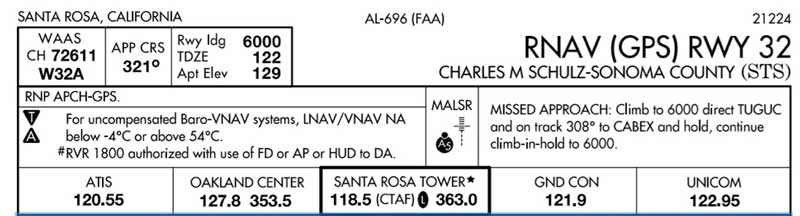

If you’re taking a flight to go visit lovely Santa Rosa, California, you will likely be going to the former Santa Rosa Army Airfield, which has long since been rebranded the Charles M. Schulz -Sonoma County Airport. My brother (recently retired as Congress’s expert on military aviation – yes, I come from an interesting family) shared with me the image that you see here: a Federal Aviation Administration approach plate for the airport. It contains a wide variety of information that could be useful in flight navigation, including reporting points used to identify when an aircraft is getting close to the field. While you may be familiar with the unique three-letter code that each airport has, you may be less familiar with the five-digit codes assigned to these reporting points.
Let’s take a look at these points:

There’s PIGPN!
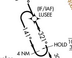
Looks like you can go into a holding pattern around LUSEE.

And there’s an intersection at WDSTC! (I’m not sure that I’d rely on WDSTC when one is seeking a stable flight path.)
Someone, obviously, was having a bit of fun.